


Chapter 19.800
APPENDICES
The purpose of the appendices is to provide supporting documentation to assist in the implementation of the ordinance codified in this title.
Contents:
Appendix A Washington State Wetlands Rating System Categories.
Appendix B Washington State DNR Stream Typing System.
Appendix C Kitsap County GIS Database of Critical Areas Information.
Appendix D Site Development Figures.
Appendix E Kitsap County Critical Area and Buffer Notice to Title.
Appendix F Critical Area Decision Types.
Appendix G Kitsap County Department of Community Development Wetland Buffer Alteration General Authorization Form.
Appendix A – Washington State Wetlands Rating System Categories (See Section 19.200.210)
This system utilizes a four-tier process. The following text includes an additional categorization system for wetlands.
A. Category I Wetlands are:
1. Wetlands that 1) represent a unique or rare wetland type; or 2) are more sensitive to disturbance than most wetlands; or 3) are relatively undisturbed and contain ecological attributes that are impossible to replace within a human lifetime; or 4) provide a high level of functions.
2. Wetlands with high quality native or regionally rare wetland communities with irreplaceable ecological functions including, but not limited to, sphagnum bogs and fens, estuarine wetlands, mature forested wetlands, or wetlands which qualify for inclusion in the Natural Heritage Information System.
3. Wetlands scoring 70 points or more (out of 100) on the questions related to functions in the Washington State Wetland Rating System for Western Washington, Revised 2004.
B. Category II Wetlands are:
1. Wetlands that are difficult, though not impossible, to replace, and provide high levels of some functions.
2. Wetlands which are disturbed and may be estuarine and interdunal greater than 1 acre.
3. Wetlands scoring between 51 – 69 points (out of 100) on the questions related to functions in the Washington State Wetland Rating System for Western Washington, Revised 2004.
C. Category III Wetlands are:
1. Wetlands that are 1) wetlands with a moderate level of functions (scores between 30 – 50 points) and 2) interdunal wetlands between 0.1 and 1 acre in size.
2. Wetlands scoring between 30 – 50 points and have generally been disturbed in some ways, and are often less diverse or more isolated from other natural resources in the landscape than Category II wetlands.
D. Category IV Wetlands are:
1. Wetland with the lowest levels of function (scores less than 30 points) and are often heavily disturbed.
2. Wetlands that may provide some important functions and have a high probability for successful replacement and/or improvement.
(Ord. 351 (2005) § 37 (part), 2005)
Appendix B – Washington State Department of Natural Resources Stream Typing System
|
Permanent Water Typing |
Previous Water Typing |
|
Stype S |
Type 1 |
|
Type F |
type 2 and 3 |
|
Type Np |
Type 4 |
|
Type Ns |
Type 5 |
A. “Type S Streams” are those surface waters which meet the criteria of the Washington Department of Natural Resources, WAC 222-16-030(1) as now or hereafter amended, as a Type S Water and are inventoried as “Shorelines of the State” under the Shoreline Management Master Program for Kitsap County, pursuant to RCW Chapter 90.58. Type S waters contain salmonid fish habitat.
B. “Type F Streams” are those surface waters, which meet the criteria of the Washington Department of Natural Resources, WAC 222-16-030(2) as now or hereafter amended, as Type F Water. Type F streams contain habitat for salmonid fish, game fish and other anadromous fish.
C. “Type Np Streams” are those surface waters, which meet the criteria of the Washington Department of Natural Resources, WAC 222-16-030(3) as now or hereafter amended, as Type Np Water. Type Np waters do not contain fish habitat.
D. “Type Ns Streams” are those surface waters, which meet the criteria of the Washington Department of Natural Resources, WAC 222-16-030(4) as now or hereafter amended, as a Type Ns Water. These streams are areas of perennial or intermittent seepage, ponds, and drainage ways having short periods of spring or storm runoff. Type Ns waters do not contain fish.
(Ord. 351 (2005) § 36 (part), 2005)
Appendix C – Kitsap County’s GIS Database of Critical Areas Information
|
CRITICAL AREA |
GIS DATA |
INFORMATION SOURCE |
|
Wetlands |
National Wetlands Inventory Soil Survey of Kitsap County |
U.S. Fish and Wildlife Service U.S. Dept. of Agriculture — Natural Resource Conservation Service |
|
Fish And Wildlife Habitat Conservation Areas |
National Wetlands Inventory Non-game & Priority Species Habitat Database Washington Rivers Information System Database Waters of Washington State Washington Coastal Zone Atlas |
U.S. Fish and Wildlife Service WA. Dept. of Fish and Wildlife WA. Dept. of Fish and Wildlife WA. Dept. of Natural Resources WA Dept. of Ecology |
|
Frequently Flooded Areas |
Flood Insurance Rate Map |
Federal Emergency Management Agency |
|
Geologically Hazardous Areas |
Washington Coastal Zone Atlas Soil Survey of Kitsap County Quaternary Geology and Stratigraphy of Kitsap County Light Distancing and Radar (LiDAR) Mapping |
WA Dept. of Ecology U.S. Dept. of Agriculture — Natural Resource Conservation Service Jerald Deeter, 1979 Puget Sound LiDAR Consortium |
|
Aquifers |
Critical Aquifer Recharge Areas Aquifer Recharge Areas of Concern Principal Aquifers Soil Survey of Kitsap County |
Kitsap Public Utilities District (PUD) #1 Kitsap PUD #1 Kitsap PUD #1 U.S. Dept. of Agriculture — Natural Resource Conservation Service |
(Ord. 351 (2005) § 37 (part), 2005)
Appendix D – Site Development Figures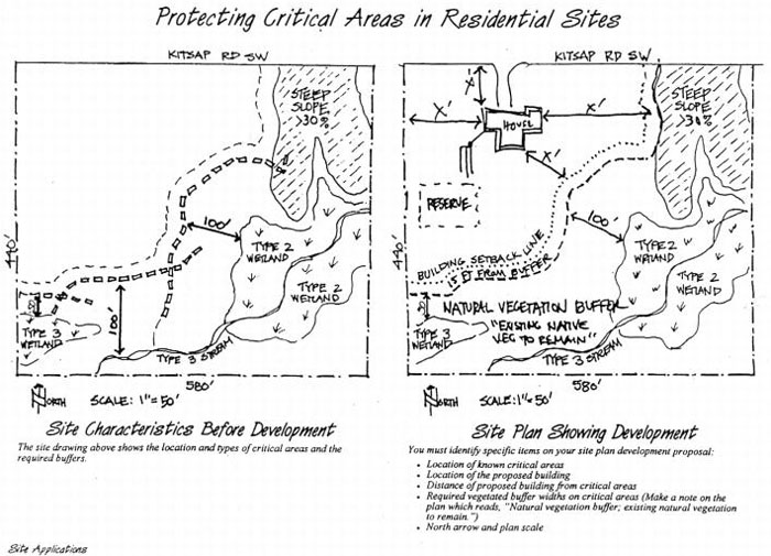
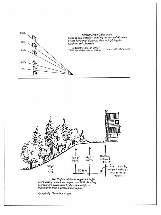
(Ord. 351 (2005) § 37 (part), 2005)
Appendix E – Kitsap County Critical Area and Buffer Notice
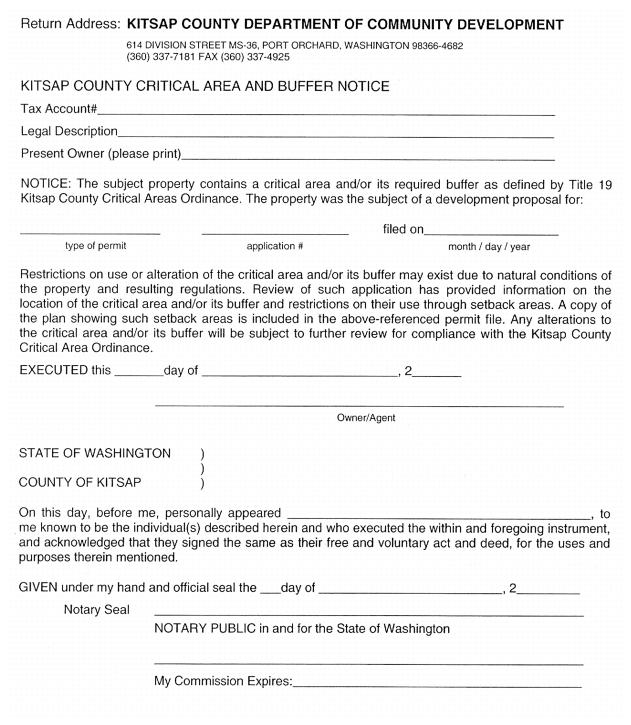
(Ord. 351 (2005) § 37 (part), 2005)
Appendix F – Critical Area Decision Types
Below are the decisions and their respective decision-making bodies included in Title 19 of the Kitsap County Code.
|
CRITICAL AREA DECISION TYPES |
|||
|
|
Type I |
Type II |
Type III |
|
Written Notice (To Interested Parties and Neighbors Within 400 feet of Project) |
No |
Yes |
Yes |
|
Decision Making Body |
Director |
Director |
Hearing Examiner (Public Hearing) |
|
WETLANDS |
|||
|
Uses within Wetlands and Buffers |
X |
|
|
|
Mitigation Plans/Requirements |
X |
|
|
|
Buffer Averaging |
X |
|
|
|
Administrative Buffer Reduction (<25%) |
X |
|
|
|
Variance (>25%) |
|
|
X |
|
Appeals |
|
|
X |
|
STREAMS AND SHORELINES |
|||
|
Buffer Averaging |
X |
|
|
|
Administrative Buffer Reduction (<25%) |
X |
|
|
|
Administrative Buffer Reduction (25-50%) |
|
X |
|
|
Variance (>50%) |
|
|
X |
|
Appeals |
|
|
X |
|
WILDLIFE CONSERVATION AREAS |
|||
|
Habitat Management Plan Approval |
X |
|
|
|
Appeals |
|
|
X |
|
GEOLOGICALLY HAZARDOUS AREAS (STEEP SLOPES) |
|||
|
Buffer/Setback Reduction (with Geotechnical Report Approval) |
X |
|
|
|
Appeals |
|
|
X |
|
CRITICAL AQUIFERS RECHARGE AREAS |
|||
|
Hydrological Report Approval |
X |
|
|
|
Appeals |
|
|
X |
(Ord. 351 (2005) § 37 (part), 2005)
APPENDIX G – Kitsap County Department of Community Development Wetland Buffer Alteration General Authorization Form.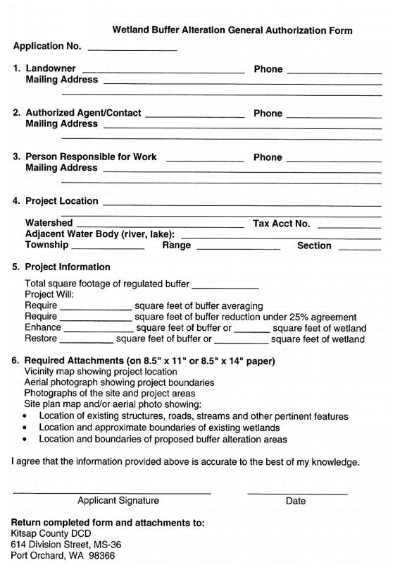
(Ord. 351 (2005) § 37 (part), 2005)