4.2.5
Projects shall employ On-site Stormwater Management BMPs in accordance with the following project thresholds, standards, and lists to infiltrate, disperse, and retain stormwater runoff on site to the extent feasible without causing flooding or erosion impacts.
4.2.5.1 Project Thresholds
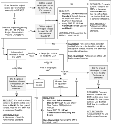
Different compliance paths for meeting Minimum Requirement #5 are available depending on whether the project is a small project or a large project per the definitions in Chapter 12.08 KCC.
Small Projects that Trigger Only Minimum Requirements #1–#5
Small projects for which not all of the nine minimum requirements apply (Chapter 12.08 KCC) shall either:
-
Use any Flow Control BMP(s) desired to achieve the LID Performance Standard (see the LID Performance Standard provided below) and apply Post-Construction Soil Quality and Depth. Project proponents selecting this option cannot use Rain Gardens. They may choose to use Bioretention as described in Volume II, Chapter 5 and Volume V, Chapter 5 of the Ecology Manual to achieve the LID Performance Standard.
or
-
Use LID BMPs from List #1 (Table I-4.3) for all surfaces within each type of surface included in List #1;
Large Projects that Trigger Minimum Requirements #1–#9
Large projects for which all nine minimum requirements apply (Chapter 12.08 KCC) shall meet the requirements in Table I-4.2. Note that the requirements for large projects differ based on whether or not the project is located inside a UGA, a Census Urbanized Area (UA), or a rural area located outside both the UGA and UA. Refer to the UGA, UA, and rural area mapping available on the County’s Community Development Maps/GIS web page.
|
Project Type and Location |
Requirement |
|---|---|
|
Inside UGA or UA |
|
|
New development on any parcel inside the UGA, or new development inside a UA on a parcel less than 5 acres |
Applicant option: |
|
New development outside the UGA but inside a UA on a parcel of 5 acres or larger |
LID Performance Standard and Post-Construction Soil Quality and Depth |
|
Redevelopment on any parcel inside the UGA, or redevelopment outside a UGA but inside a UA on a parcel less than 5 acres |
Applicant option: |
|
Redevelopment outside the UGA but inside a UA on a parcel 5 acres or larger |
LID Performance Standard and Post-Construction Soil Quality and Depth |
|
Outside UGA and UA (Rural Areas) |
|
|
New development |
Applicant option: |
|
Redevelopment |
|
Notes:
|
|
Flow Control Exempt Projects
Projects qualifying as flow control exempt in accordance with MR #7 shall either:
-
Use LID BMPs from List #3 (Table I-4.3) for all surfaces within each type of surface included in List #3;
or
-
Use any Flow Control BMP(s) desired to achieve the LID Performance Standard (see the LID Performance Standard provided below) and apply Post-Construction Soil Quality and Depth.
If the project has multiple TDAs, all TDAs must be Flow Control exempt per Minimum Requirement #7 for the project to use these options.
4.2.5.2 Low Impact Development Performance Standard
The LID Performance Standard compliance method for Minimum Requirement #5 requires modeling the proposed flow control BMPs to demonstrate the flow reduction as described below. Note that in order to meet the LID Performance Standard, the chosen flow control BMPs will most likely need to include infiltration. Drainage design using the LID Performance Standard shall be performed by or under the direction of a professional engineer licensed to practice in Washington State.
Stormwater discharges shall match developed discharge durations to pre-developed durations for the range of pre-developed discharge rates from 8% of the 2‑year peak flow to 50% of the 2‑year peak flow. Refer to Vol I–4.2.7.3 Flow Control Performance Standard for information about the assignment of the pre-developed condition. Project sites that must also meet Minimum Requirement #7 must match flow durations between 8% of the 2‑year flow through the full 50‑year flow.
Designers selecting this option cannot use Rain Gardens to achieve the LID Performance Standard. They may choose to use Bioretention to achieve the LID Performance Standard.
4.2.5.3 The List Approach
The List Approach compliance method for Minimum Requirements #5 requires evaluating the BMPs in Table I-4.3.
For each surface type (e.g., lawn and landscaped areas, roofs, and other hard surfaces), evaluate the feasibility of the BMPs in the order listed, and use the first BMP that is considered feasible. Once a BMP is deemed feasible and used for a surface, no other BMP from the list is necessary for that surface.
If all BMPs in the list are infeasible, then the designer must document the site conditions and infeasibility criteria used to deem each BMP infeasible. This documentation will demonstrate compliance with Minimum Requirement #5.
Feasibility shall be determined by evaluation against:
-
Design criteria, limitations, and infeasibility criteria identified for each BMP in Volume II, Chapter 5; and
-
Competing Needs Criteria listed in Volume I, Section 3.4.5 of the Ecology Manual.
|
List #1 |
List #2 |
List #3 |
|---|---|---|
|
Surface Type: Lawn and Landscaped Areas |
||
|
Surface Type: Roofs |
||
| 1. Downspout Full Infiltration | ||
|
2. Bioretention or Rain Gardens |
2. Bioretention |
|
| 2. Downspout Dispersion Systems | ||
| 3. Perforated Stub-out Connections | ||
|
Surface Type: Other Hard Surfaces |
||
|
2. Permeable Pavements (not required for rural residential areas) |
||
|
3. Bioretention |
||
|
Notes for using the List Approach:
|
||
Figure I-4.3. Flow Chart for Determining MR #5 Requirements.
