2.1.6
To maintain existing hydrologic patterns and important features, onsite hydrologic processes, patterns, and physical features must be understood and documented. This step requires documenting the following feature types, among others found on site that may influence drainage patterns:
-
Streams
-
Wetlands
-
Native soils and vegetation (see also Vol I–2.1.7 Vegetation)
-
Seeps
-
Springs
-
Closed depressions (see also Vol I–2.1.5 Topography)
-
Drainage swales and ditches
-
Signs of erosion
-
Natural discharge location(s)
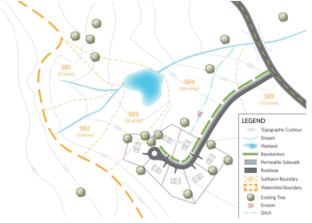
To the extent possible, this step should be undertaken during wet periods. See Figure I-2.1 for an example map of hydrologic features for a hypothetical subdivision development.
Figure I-2.1. Example Map Documenting Existing Hydrologic Features.
Detailed subbasin delineation provides several advantages as follows:
-
Individual practices receive smaller hydraulic and pollutant loads.
-
Small-scale practices can be arranged in the project efficiently and save space for other amenities.
-
Individual LID BMPs can be accurately sized based on the appropriate tributary drainage areas and their cumulative performance across the site can be evaluated.
